 Antiques (AU)
Africa Maps
Asia Maps
Australia/Oceania Maps
Celestial Maps
Central America/Caribbean Maps
Curiosities Maps
Digital Maps
Europe Maps
Map & Globe Mixed Lots
Map & Globe Reproductions
North America Maps
South America Maps
World & Celestial Globes
World Maps

-
$219.11 AUD

 Map of Holland, Circa 1730
-
$343.81 AUD
 A New Map of South America, drawn from the latest Discoveries, ca 1700-1730
-
$1008.91 AUD
 Antique Map Of The Malabar Coast By Baldaeus (1744) Canara Decan Old Collectible
-
$210.68 AUD
 Antique Map Switzerland According to the Best Authorities Carey 1795 Engraving
-
$1850.00 AUD
 "CARTE RÉDUITE DES TERRES AUSTRALES" (Australia), Jacques Nicolas BELLIN, 1753.
-
$30.00 AUD
 1720 Emmanuel Bowen Antique British Road Map - Prestain/New Radnor to Carmarthen
-
$30.00 AUD
 1720 Emmanuel Bowen Antique British Road Map Chester - Cardiff + Brecknock Wales
-
$252.82 AUD
 1787 Rigobert Bonne Mappemonde Occidental Western Hemisphere Antique Map
-
$380.00 AUD
 “CARTE DES ISLES DE PAPOUS” (Papua New Guinea), JEAN LATTRÉ, c.1750.
-
$38.75 AUD
 1898 ORIGINAL MAP WORLD AMERICA ASIA AUSTRALIA EUROPE AFRICA sea currents OCEANS
-
$210.01 AUD
 1783 NEW & ACCURATE MAP OF NORTH AMERICA INC NOOTKA SOUND & ASIA by BOWEN *
-
$126.41 AUD
 1767 Kingdom of Hungary antique map by Clouet ~ 22.8" x 17.1" - hand color
-
$168.53 AUD
 Antique Map - Joseph Roux - Harbour Plan Sirie - Port of Alexandretta - F5
-
$116.30 AUD
 Original Antique 1780 Map of Europe by Bonne
-
$1008.91 AUD
 Antique Map Regionum Choromandel, Golconda Et Orixa Nova Et Accurate Descriptio
-
$167.70 AUD
 Antique Map Grand Expedition Holland 1799 early paper
-
$168.53 AUD
 Antique Map - Joseph Roux - Harbour Plan - Port of Saint Antoine - Lemnos - F5
-
$219.09 AUD
 Antique Map - Joseph Roux - Harbour Plan - Gulf of Arzew in Turkey - F5
-
$168.53 AUD
 Antique Map - Joseph Roux - Harbour Plan - Port of Parenso-Croatia - Pula - F5
-
$252.80 AUD
 Antique Map - Joseph Roux - Strait of Bonifacio - Corsica & Sardinia - F5
-
$219.09 AUD
 Antique Map - Joseph Roux - Harbour Plan - Port of Ancona in Italy - F5
-
$168.53 AUD
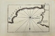 Antique Map - Joseph Roux - Harbour Plan - Boun Algiers and Port Geneva - F5
-
$252.80 AUD
 Antique Map - Joseph Roux - Harbour Plan - Port of Syracuse / Saragosa - F5
-
$219.09 AUD
 Antique Map - Joseph Roux - Harbour Plan - Saint-Drely Bay in Turkey - F5
-
$219.09 AUD
 Antique Map - Joseph Roux - Harbour Plan - Constantinople Bosphorus Canal - F5
-
$50.56 AUD
 1795 Guthrie Ireland - 9.2" x 8.2" Authentic & original antique map
-
$650.00 AUD
 "CARTE GENERALE DE L'ITALIE" Marechal de Maillebois, 1775.
-
$151.69 AUD
 c1744 Belgium by M. Seutter - Germaniae Inferioris sive Belgii - antique map
-
$26.97 AUD
 Map Sherman's Army Virginia Operations 1871 Victorian Lithograph History DWAA12
-
$20.23 AUD
 Map Revolutionary War South Colonies 1871 Victorian Woodcut Print History DWAA12
-
$67.40 AUD
 1779 Bonne Map - Southeast Brazil Rio de Janeiro Uruguay Paraguay Argentina
-
$202.25 AUD
 Artesia (Belgium/Northern France) Antique Engraved Map M. Seutter 18th Century
-
$2903.55 AUD
 Antique 1755 Map ~ British & French Dominions North America ~ Mitchell / Throop
-
$379.22 AUD
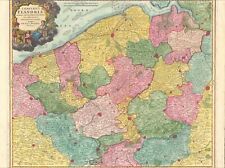 1735 Flanders Belgium antique map by Homann ~ 25" x 20" beautiful full color
-
$294.95 AUD
 1743 Konstanz Württemberg Swabia + antique map by Homann ~ 25" x 20" full color
-
$294.95 AUD
 1735 Austria & more antique map by Homann ~ 24.8" x 21.1" beautiful color
-
$379.22 AUD
 1735 Duchy Luxembourg antique map by Homann ~ 25" x 20" beautiful full color
-
$758.45 AUD
 1749 Formosa / Taiwan antique map by Bellin / Schley ~ 18.7" x 11.7" China rare
-
$497.20 AUD
 Antique Prussia Germany Map Jan Kool Watermark Late 18th/Early 19th Century
-
$150.00 AUD
 C 1630 Liege Belgium Hondius / Mercator - antique map Leodiensis Dioecesis
-
$335.40 AUD
 1735 Mosellae Fluminis antique map by Homann ~ 25" x 20" beautiful full color
-
$50.56 AUD
 c1720 Spain & Portugal 9" x 7.6" Authentic & original antique map
-
$210.68 AUD
 1767 Asia's Lakes, Rivers & Mountains antique map by Clouet ~ 22.7" x 17.1"
-
$399.45 AUD
 1798 Map of Switzerland, Lake Geneva, Antique Linen
-
$193.83 AUD
 1767 Mongol Empire / India antique map by Clouet ~ 22.8" x 17.1" - hand color
-
$278.10 AUD
 A Map of the Seat of War in France 1795 Mathew Carey Belgium Germany Engraving
-
$210.68 AUD
 1767 Asia's Islands Capes & Seaports antique map by Clouet ~ 22.7" x 17"
-
$294.95 AUD
 1767 America's Lakes, Rivers & Mountains antique map by Clouet ~ 22.8" x 16.8"
-
$379.22 AUD
 1735 Burgundy France antique map by Homann ~ 25" x 20" beautiful full color
-
$335.40 AUD
 1735 Brabant Belgium antique map by Homann ~ 25" x 20" beautiful full color
-
$421.36 AUD
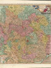 1735 Franconia Bavaria antique map by Homann ~ 24.7" x 21.2" beautiful color
-
$109.55 AUD
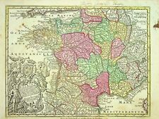
 1767 Mineralogical France antique map by Clouet ~ 22.8" x 16.7" - hand color
-
$503.95 AUD
 1642 Burgundy France antique map by W. Blaeu ~ 23.8" x 20.25" beautiful color
-
$335.40 AUD
 1735 Saxony Germany antique map by Homann ~ 25" x 20" beautiful full color
-
$109.55 AUD
 1767 "Commercante" France antique map by Clouet ~ 22.7" x 17.1" - hand color
-
$109.55 AUD
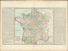 1767 General France antique map by Clouet ~ 23" x 17.1" - hand color
-
$160.12 AUD
 Cape of Good Hope South Africa Bellin Map 1773 Carte de la Baye de la Table
-
$166.86 AUD
 1729 Canary Islands map by Robert Vaugondy - circa 1750 -
-
$335.40 AUD
 1735 Lorraine France antique map by Homann ~ 25" x 20" beautiful full color
-
$252.82 AUD
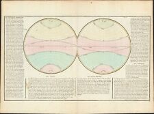
 1767 Hemispheres showing seas & oceans antique map by Clouet ~ 22.7" x 16.6"
-
$58.99 AUD
 1795 Guthrie Hindostan or India - 9.9" x 8.3" Authentic & original antique map
-
$311.81 AUD
 1735 Lower Saxony Germany antique map by Homann ~ 24.6" x 21.2" beautiful color
-
$421.36 AUD
 1767 Des Vents / Compass rose antique map by Clouet ~ 22.6" x 16.7"
-
$278.10 AUD
 1767 Systems of the World antique map by Clouet ~ 22.5" x 17"
-
$50.56 AUD
 1795 Guthrie Germany - 10" x 8.5" Authentic & original antique map
-
$227.53 AUD
 1767 North South America Hemisphere antique map by Clouet ~ 22.5" x 16.6" color
-
$294.95 AUD
 1767 America's Islands, Capes & Seaports antique map by Clouet ~ 22.8" x 17.1"
-
$126.41 AUD
 1767 Ecclesiastical France antique map by Clouet ~ 22.6" x 16.6" - hand color
-
$193.83 AUD
 1767 Kingdom of Poland antique map by Clouet ~ 22.8" x 17.1" hand color
-
$151.69 AUD
 1767 Egypt antique map by Clouet ~ 22.8" x 17.1" hand colored
-
$210.68 AUD
 1762 France by M. Seutter - Gallia Concinata ad Magnum authentic antique map
-
$758.45 AUD
 1710 Hainault Namur & Cambray Antique Map by John Senex ~ 26.1" x 20.8" - rare
-
$126.41 AUD
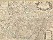
 1767 Governments of France antique map by Clouet ~ 22.6" x 16.8" - hand color
-
$193.83 AUD
 1767 Hemispheres showing regions antique map by Clouet ~ 22.6" x 16.9"
-
$126.41 AUD
 1767 General map of France antique map by Clouet ~ 22.9" x 16.6" - hand color
-
$421.36 AUD
 1735 Map of Postal Routes of Germany by Homann ~ 23.6" x 20"
-
$421.36 AUD
 1767 Armillary Sphere poles tropics + more antique map by Clouet ~ 22.5" x 16.9"
-
$109.55 AUD
 1767 Sweden Norway & Denmark antique map by Clouet ~ 22.8" x 16.8" hand color
-
$58.99 AUD
 1795 Guthrie 7 United Provinces Netherlands 9.7" x 8.3" Authentic & original map
-
$168.54 AUD
 1767 Africa's Islands, Capes & Seaports antique map by Clouet ~ 22.8" x 17.1"
-
$75.84 AUD
 1795 Guthrie Poland Showing Claims 10.1" x 8.4" Authentic & original antique map
-
$497.20 AUD
 c.1700 Wells New Map of the North Part of Antient Africa Duke of Gloucester
-
$193.83 AUD
 1767 Bohemia & Silesia antique map by Clouet ~ 22.6" x 17.1" - hand color
-
$193.83 AUD
 1767 Hemispheres showing climate zones antique map by Clouet ~ 22.6" x 16.9" # 2
-
$210.68 AUD
 Antique 18th C. A New and Accurate Map of Africa by Thomas Bowen Engraving Print
-
$294.95 AUD
 1767 World Hemispheres latest observations antique map by Clouet ~ 22.7" x 16.3"
-
$109.55 AUD
 1767 Northern Italy antique map by Clouet ~ 22.8" x 17.1" - hand color
-
$50.56 AUD
 1795 Guthrie Netherlands - 9.7" x 7.9" Authentic & original antique map
-
$109.55 AUD
 1767 Kingdom of Portugal antique map by Clouet ~ 23.1" x 16.6" - hand color
-
$168.54 AUD
 1767 Swabia & Bavaria Germany antique map by Clouet ~ 23.1" x 17.1" - hand color
-
$227.53 AUD
 1767 Hemispheres showing climate zones antique map by Clouet ~ 22.6" x 16.9"
-
$168.54 AUD
 1767 Europe's Islands Capes & Seaports antique map by Clouet ~ 23" x 16.8"
-
$210.68 AUD
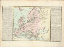
 Antique 18th C. New and Accurate Map of Europe by Thomas Bowen Print
-
$109.55 AUD
 1767 General Spain antique map by Clouet ~ 23" x 17.1" - hand color
-
$193.83 AUD
 1767 Westphalia Germany antique map by Clouet ~ 23" x 17.1" - hand color
-
$235.96 AUD
 1767 Hemispheres showing the soil / land antique map by Clouet ~ 22.6" x 17"
-
$109.55 AUD
 1767 Provinces of Spain antique map by Clouet ~ 22.6" x 17.1" - hand color
-
$166.86 AUD
 1607 Lotharingia by G. Mercator - antique map France Luxembourg Germany
-
$193.83 AUD
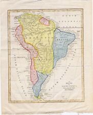
 1767 South America antique map by Clouet ~ 23.1" x 17.1" - Hand Colored
-
$176.97 AUD
 1767 Hemispheres with Peoples distribution antique map by Clouet ~ 22.6" x 16.9"


